
We currently have 8 off leash dog walking areas in ‘Dog friendly Byron Shire‘. View an interactive map with a description of each of off leash areas. Information about responsible dog ownership
read moreWe currently have 8 off leash dog walking areas in ‘Dog friendly Byron Shire‘. View an interactive map with a description of each of off leash areas. Information about responsible dog ownership
read more
Jason from Hubway design has been a great support and value to the Zero Emissions Byron Project, including his ongoing work as a community volunteer, and working with us to get the site developed and launched within a tight deadline.
Tiffany Harrison – Co-ordinator – Zero Emissions Byron
Live Byron is a distinctively local blog by photojournalist Veda Dante, whose daily work for the biggest newspapers on the North Coast gives her a unique insight into local events and the characters behind them. Explore the chefs and entrepreneurs of the region’s best restaurants, get a birds-eye-view of Byron with a local pilot who built his own plane, and meet the space scientist whose hinterland observatory stands starkly against its subtropical backdrop. From major events like the Mullum Music, Falls and Byron Bay Surf festivals to local showcases like the Bruns Hot Rod and Bangalow Designers Market, Live Byron gives you a personal insight into the eclectic, creative, kind-hearted and confused people behind the news. Live Byron also provides an intimate insight into family life on a Byron Bay hinterland farm, where invasive weeds are being replaced by native rainforest, tractors regularly break down, children learn about bushfire safety,
read more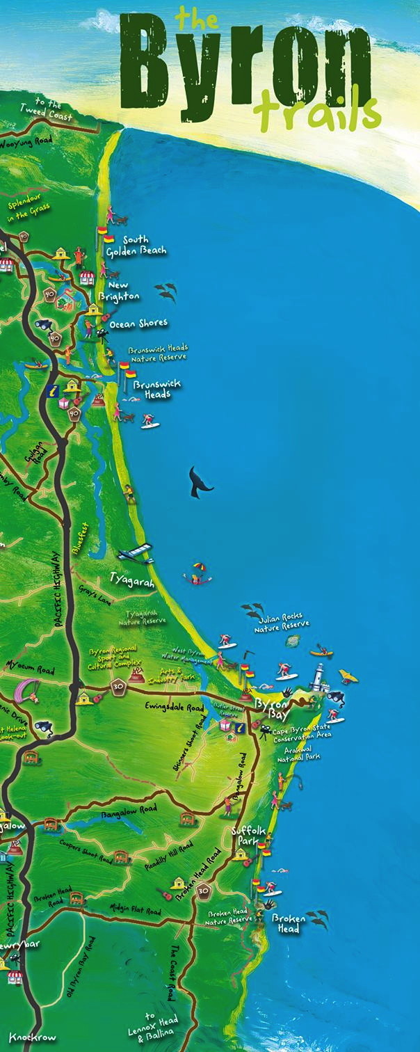
Billinudgel Nature Reserve South Golden Beach New Brighton Beach North Wall Brunswick Heads Christmas Beach (north bank Brunswick River) Torikina (south bank Brunswick River) Brunswick Heads Main Beach Tyagarah Nature Reserve (clothes optional) Belongil Beach The Wreck Byron Bay Main Beach Clarks Beach The Pass Wategos Little Wategos Tallow Beach Suffolk Park Kings Beach (Broken Head) Brays Beach (Broken Head) Map is part of the Byron Trails Map. Surf life saving services in Byron Shire are provided at specific beaches within Byron Shire Council during the NSW and Queensland School Holidays. Beach patrols are also provided by Surf Life Saving Volunteers at Brunswick Heads and Byron Bay Main Beach on weekends and Public Holidays from Saturday 20 September 2014 to Sunday 26 April 2015. (source: Byron Shire Council) Local marine habitats include exposed and sheltered sandy beaches, rocky shores, rocky reefs, submerged pinnacles, small rocky islands, coral communities, riverine estuaries,
read more
Jason is an excellent trainer, very considerate and patient, and clearly knows his way round all the website paraphanalia of permissions, nested menus, edits, shortcuts and the whole shebang.
Param Berg – Gas Field Free Byron Shire
The following are the BSC approved holiday parks & camping grounds. Source: Byron Shire Council website In New South Wales there are a number of roadside rest areas where you can stop and refresh. For more information and locations see Roads and Maritime Services / Rest areas Byron Bay First Sun Holiday Park Byron Bay Lawson Street Byron Bay 02 6685 6544 info@firstsunholidaypark.com.au firstsunholidaypark.com.au Byron Bay Tourist Village 399 Ewingsdale Road Byron Bay 02 6685 7378 touristvillage@byronbayresorts.com www.byronbaytouristvillage.com.au Glen Villa Resort 80-86 Butler Street Byron Bay 02 6685 7382 glenvilla@byronbayresorts.com www.glenvillaresort.com.au Clarkes Beach Holiday Park Off Lighthouse Road Byron Bay 02 6685 6496 clarkesbeach@nchp.com.au www.northcoastholidayparks.com.au Red Devil Park Camping Corner Bangalow Road & Broken Head Road Byron Bay 0402 937 116. red_devilpark@hotmail.com www.byronbaycamping.com.au Beaches of Byron 5 – 37 Brokenhead Road Byron Bay 02 6685 6751 Bookings@BeachesofByron.com.au www.beachesofbyron.com.au Belongil Fields Caravan Park 394 Ewingsdale Road Byron Bay 02 6680 8999
read more
Byron Shire Council Local Government Area (LGA) is located on the north coast of NSW and shares its boundaries with the Tweed, Lismore, and Ballina LGAs. The Northern Rivers comprises the seven Local Government Areas of Ballina, Byron, Clarence Valley, Kyogle, Lismore, Richmond Valley and Tweed Shire. Brisbane is approximately 200 kilometres north and Sydney approximately 800 kilometres to the south. Map of Byron Shire, NSW The principal economic driver in the Byron LGA is tourism, with an estimated value of $370.0m in 2006 from about 1.3m visitors. Tourism has a major impact on the retail, food, accommodation, construction and wholesale sectors. Agriculture and related value added products, and the creative industries also contribute substantially to the economy. Byron Shire LGA “Byron Shire is located at Australia’s eastern-most point with a population of almost 29,000. It is a thriving community where residents and visitors live, work and play in a
read more
The map is FREE and can be picked up at Visitor Information Centres, local businesses, trade shows and expos and local accommodation operators and venues. Source: Byron Shire Council website See Byron Shire Visitor Information Centres See Camping areas in Byron Shire
read moreSuburb/Town Post Code Andersons Hill 2482 Bangalow 2479 Billinudgel 2483 Binna Burra 2479 Blind Mouth 2482 Booyong 2480 *** Broken Head 2481 *** Brunswick Heads 2483 Byron Bay 2481 Clunes 2480 *** Coopers Creek 2480 Coopers Lane 2482 Coopers Shoot 2479 Coorabell 2479 Crabbes Creek 2483 *** Durrumbul 2482 Eureka 2480 Everitts Hill 2482 Ewingsdale 2481 Federal 2480 Golden Beach 2483 Goonengerry 2482 Huonbrook 2482 Koonyum Range 2482 Lavertys Gap 2482 Main Arm 2482 Mcleods Shoot 2479 Middle Pocket 2483 Montecollum 2482 Mullumbimby 2482 Mullumbimby Creek 2482 Myocum 2481 Nashua 2479 New Brighton 2483 Newrybar 2479 *** Ocean Shores 2483 Ocean Shores North 2483 Opossum Creek 2479 Palmwood 2482 Palmwoods 2482 Possum Creek 2479
read more
The local Arakwal Aboriginal people’s name for the area is Cavvanbah, meaning “meeting place”. The history of Europeans in Byron Bay began in 1770, when Captain James Cook found a safe anchorage and named Cape Byron after Captain John Byron, who circumnavigated the globe in 1764-66 and thus preceded Cook on the Pacific. In the 1880s, when Europeans settled more permanently, streets were named for other English writers and philosophers. Byron Bay is part of the erosion caldera of an ancient shield volcano, the Tweed Volcano, which erupted 23 million years ago. The volcano formed as a result of the Indo-Australian Plate moving over the East Australia hotspot. 1770: Captain Cook sails past and names Cape Byron as a tribute to his fellow navigator, Vice-Admiral John Byron, grandfather of the famous poet. The area was called Cavvanba, meaning meeting place, by the local Arakawal and Minjangbal tribes. 1840s: The “Big
read more